SMPDBK
Simulate Downstream Flooding Produced by a Dam Failure
Application:Dam Break Hydraulic Modeling
Method:n/a
Model Type:1D
Developer:National Weather Service
Why SMPDBK with WMS?
WMS provides a custom interface to the SMPDBK model offering a simple way to set model parameters and a graphical user interface to run the model and visualize the results. Gather background data from a variety of sources from GIS to CAD and access online data from numerous databases of maps, images, elevation, land use, and soil data. WMS allows you to interact with models in true 3D taking advantage of optimized OpenGL graphics and to create photo-realistic renderings and animations for PowerPoint, print, and web presentations.
Try WMS Free for 14 Days >Purchase WMS with SMPDBK >
SMPDBK Description:
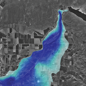
The Simplified Dam-Break (SMPDBK) was developed by the National Weather Service (NWS) for predicting downstream flooding produced by a dam failure. This program is still capable of producing the information necessary to estimate flooded areas resulting from dam-break floodwaters while substantially reducing the amount of time, data, and expertise required to run a simulation of the more sophisticated unsteady NWS DAMBRK, or now called FLDWAV. The SMPDBK method is useful for situations where reconnaissance level results are adequate, and when data and time available to prepare the simulation are sparse. Unlike the more sophisticated versions of DAMBRK and FLDWAV, the SMPDBK method does not account for backwater effects created by natural channel constrictions of those due to such obstacles as downstream dams or bridge embankments.
The input required for a SMPDBK model is a stream centerline, cross sections, and information regarding the storage and failure of the dam being modeled. WMS saves the model data to a properly formatted input file for SMPDBK and then launches the executable. The executable is the same version distributed by the NWS. When a model successfully runs WMS will automatically read the results and create a water surface elevation data set that can be used for automated floodplain delineation.


