We use cookies to make your experience better. To comply with the new e-Privacy directive, we need to ask for your consent to set the cookies. Learn more.

New Map Annotation Tools in SMS 13.1
With the release of SMS 13.1 beta, a new tool has been added to allow you to have additional annotations on feature objects. SMS already provides several options for adjusting how feature objects are displayed, but now more options exist specifically for feature arcs to help make working with feature arcs easier.
Currently in recent versions of SMS, annotations can be added to label arcs. This would let you see the name of specific arcs. The color and thickness of feature arcs can also be changed. Also, specific annotation options exist for specific model coverages, such as the SRH-2D boundary conditions map coverage.
The new map annotations can add a number of new annotations to your feature arcs.With the new annotation tools, the following can also be displayed:
- An arrow indicating the the direction of the feature arc
- Tick marks to indicate the distances along the arc
- The length and number of tick marks can be adjusted along the arc
- Tick mark labels can be added
- The font and color of tick mark labels can be changed
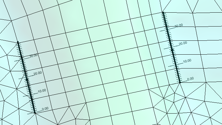
These options allow you to quickly see if an arc has been placed in the wrong direction or to check the measurement of an arc. Note that tick marks will use the units set in the project's projection.
To activate the map annotations, do the following:
- Open the Map Display Options
- Turn on the Annotations option under the Arcs section
- Click the Options button next to the Annotations option
- Turn on the different the map annotations options in the Arc Annotations Options dialog
Note, with the exception of the tick mark color, that the line width and color are still determined by the other arc display options. The display of the arcs can be adjusted before or after setting the arc annotation options.
Try out the different map annotation options in the SMS 13.1 beta today!
September 30, 2020
|
View: 1341
|
Categories: SMS
|
By: <a class="mp-info" href="https://aquaveo.com/blog/author/admin">Aquaveo Staff</a>
About the Author

Performing a Silent Install of XMS (Passwords & Hardware Locks)
October 10, 2018
Computing Basin Curve Numbers in 9 Easy Steps
May 16, 2023
Converting a NET File to an INP File
May 9, 2018
Performing a Silent Install for ALS
October 27, 2021
Tips for Finding Information on the XMS Wiki
September 25, 2019
Managing MODFLOW 6 Data: Lists, Copy Period & CSVs
April 21, 2026
5 Concepts for Mastering Surface-water Modeling
April 14, 2026
Comparing Multiple Design Alternatives in One Project
April 7, 2026
Incorporating MODFLOW 6 Groundwater Energy (GWE)
March 31, 2026
Essential DEM Clean-Up for Watershed Delineation
March 24, 2026