We use cookies to make your experience better. To comply with the new e-Privacy directive, we need to ask for your consent to set the cookies. Learn more.

Zooming with Annotations
Do you have a location in your GMS groundwater project that requires you to zoom in and out of a particular location frequently? It sometimes can become tedious to constantly have to locate the same area in the project and manually zoom in on that area using the Zoom tool. The annotation tools provide a way to make this process easier.
Zooming using the annotation tools requires the use of the Zoom to Layer command. This is done by doing the following:
- Create a new world space annotation layer. It is important that the annotation layer be set to use the world space which makes use of the project projection. Using annotation layers set to screen space will not work.
- Create annotations that mark out the zoomed in area. Using the Create Rectangular Object tool often works best for this task. Make certain that all objects added to this annotation layer are within the zoom in area.
- In the Project Explorer, right-click on the annotation layer and select Zoom to Layer. This will frame the project to the extent of the annotation objects.
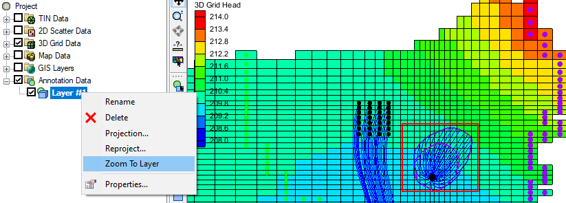
Following this method, you can zoom or pan to other locations in the project and quickly return to the area marked by the annotation layer by using the Zoom to Layer command. If there are multiple areas of interest in the project, create a separate annotation layer for each area you want to zoom in on. Doing that can make navigating around the locations of your project easier.
While we discussed doing this in GMS, it can also be done in SMS for surface-water projects. The annotation tools are similar in SMS and the Zoom to Layer is available for annotation layers in the Project Explorer.
Try out using annotations to navigation your groundwater project in GMS today!
About the Author

Performing a Silent Install of XMS (Passwords & Hardware Locks)
October 10, 2018
Computing Basin Curve Numbers in 9 Easy Steps
May 16, 2023
Converting a NET File to an INP File
May 9, 2018
Performing a Silent Install for ALS
October 27, 2021
Tips for Finding Information on the XMS Wiki
September 25, 2019
Incorporating MODFLOW 6 Groundwater Energy (GWE)
March 31, 2026
Essential DEM Clean-Up for Watershed Delineation
March 24, 2026
Essential Boundary Condition Guide
March 17, 2026
How to Delineate a Well Capture Zone Using MODPATH
March 10, 2026
How to Decide between Structured or Unstructured Grids
March 3, 2026