We use cookies to make your experience better. To comply with the new e-Privacy directive, we need to ask for your consent to set the cookies. Learn more.

How to Export Contour Lines as Shapefiles
Have you been wanting to export the contour lines in your GMS project as a shapefile so they can be opened in a different application? GMS allows exporting contour lines as a shapefile. Shapefiles are a file format used by many different GIS software applications. This post will explain how to export contour lines as shapefiles.
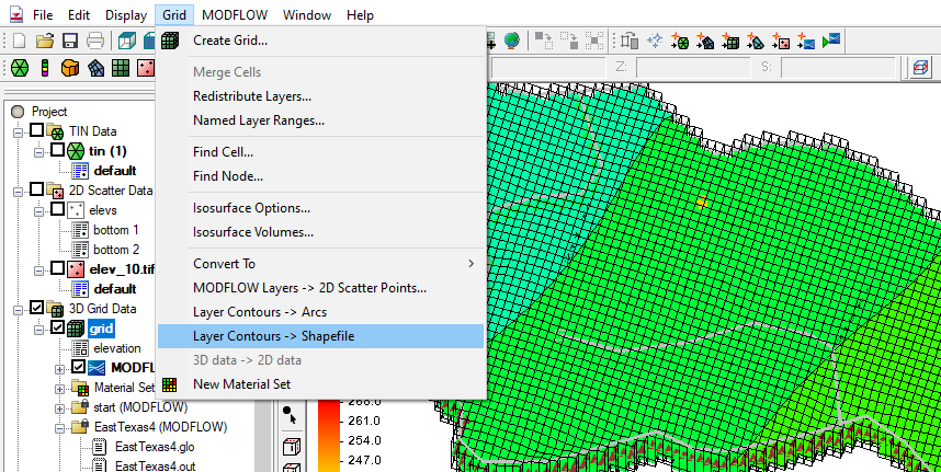
GMS contains the Layer Contours → Shapefile command to help save contour lines as a shapefile. Using this command requires your project to be set up correctly. Use the Layer Contours → Shapefile command by doing the following:
- Make sure the contours you want to convert to a shapefile are set to Linear in the Display Options. This can be accomplished by opening Display Options and clicking on Contours. In the Contour Method in the top left make certain in the dropdown that it is set to Linear.
- Make sure your Grid module is active in GMS, this can be done by clicking on the grid in Project Explorer or selecting the Grid module macro. The grid should be highlighted, meaning that it is now active.
- Go to the Grid menu and select the Layer Contours → Shapefile command. Use the dialog that appears to save your shapefile. Be sure to place it in the correct folder and name it properly. Otherwise you might lose the file.
- Now open your shapefile in the appropriate GIS software. The contour lines will appear as arc lines.
If you encounter issues with the shapefile, start with checking the folder where you saved the file. Make certain that all of the necessary files for the shapefile are there, including a projection file. Another item to check is that everything you want in the shapefile is displayed correctly in the Graphics Window before you export. Use the display options to adjust the contour lines if needed. Finally, there may be some differences between how GMS displays a shapefile and how other GIS applications display the shapefile. Opening the shapefile in GMS can help you determine if this is the case.
Try out converting contour lines to shapefiles in GMS today!
January 5, 2022
|
View: 3553
|
Categories: GMS
|
By: <a class="mp-info" href="https://aquaveo.com/blog/author/admin">Aquaveo Staff</a>
About the Author

Performing a Silent Install of XMS (Passwords & Hardware Locks)
October 10, 2018
Computing Basin Curve Numbers in 9 Easy Steps
May 16, 2023
Converting a NET File to an INP File
May 9, 2018
Performing a Silent Install for ALS
October 27, 2021
Tips for Finding Information on the XMS Wiki
September 25, 2019
Comparing Multiple Design Alternatives in One Project
April 7, 2026
Incorporating MODFLOW 6 Groundwater Energy (GWE)
March 31, 2026
Essential DEM Clean-Up for Watershed Delineation
March 24, 2026
Essential Boundary Condition Guide
March 17, 2026
How to Delineate a Well Capture Zone Using MODPATH
March 10, 2026