We use cookies to make your experience better. To comply with the new e-Privacy directive, we need to ask for your consent to set the cookies. Learn more.

Transferring Data between GMS and ArcGIS Pro
Exporting and importing data between ArcGIS Pro and GMS allows many users to improve the quality of their groundwater models. Today we explore moving data between these two applications, focusing mostly on shapefiles.
Exporting and importing shapefiles allows features that have already been digitized in one program to be transferred to another program. For instance, once data has been modeled in GMS, it can be converted to a shapefile and imported into ArcGIS Pro. Furthermore, feature objects that have already been drawn in ArcGIS Pro or GMS can be transferred to the other program and then used as feature objects for the work you’re doing there.
To start, consider exporting feature objects from GMS as a shapefile. You can draw arcs in a coverage and then use the right-click menu in the Project Explorer to export the information. There are three options for file type, so make sure to select "Shapefile (*.shp)" from the Save as type drop-down. Once you click Save in the Export Coverage dialog, another dialog opens that allows you to choose what kinds of shapefiles you want to save. There are arc, point, and polygon shapefiles. Once you've exported the shapefiles, they can be imported into ArcGIS Pro using that program’s Add Data function on the Map ribbon tab.
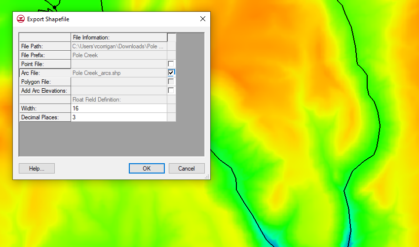
It's important to keep in mind that when GMS feature objects get exported to a shapefile, there are a couple of other file types that get exported with them. It's important to keep all of the files together because the shapefile is not complete without those other files. For example, one of the file types has projection information that lets other GIS programs, like ArcGIS Pro, know where the shapefile is located geographically. Without it, the shapefile is not attached to specific geographic coordinates, making it far less useful. You might consider putting all the files created in the shapefile together in a folder. This could help keep them together if you choose to relocate them after creating them.
GMS also allows for exporting of contour features and MODPATH particle tracking lines as shapefiles. However, these shapefiles do not appear when they are imported into ArcGIS Pro. Fortunately, there is a workaround for this issue. The shapefiles that GMS creates can be imported back into GMS after being exported. Then you can convert them to feature objects. Once they are converted to feature objects, you can use the same process described above to turn them into shapefiles that ArcGIS Pro can visualize.
GMS also has the ability to import shapefiles created or edited in ArcGIS Pro. Points, arcs, or polygons can be created in GMS, exported to ArcGIS Pro, edited in ArcGIS Pro, then saved and subsequently imported back into GMS. ArcGIS Pro also has exporting tools that can create shapefiles, CAD data, or other types of data for GMS to import.
There are other kinds of information that can be exported and imported between the two programs. Both programs have means for exporting and importing text files; 2D UGrids and other geometries in GMS can be exported as shapefiles; Rasters, scatter datasets, and other forms of data can also be transferred between GMS and ArcGIS Pro. In short, importing and exporting between these two programs has many possibilities.
Explore exporting and importing tools in GMS today!
About the Author

Performing a Silent Install of XMS (Passwords & Hardware Locks)
October 10, 2018
Computing Basin Curve Numbers in 9 Easy Steps
May 16, 2023
Converting a NET File to an INP File
May 9, 2018
Performing a Silent Install for ALS
October 27, 2021
Tips for Finding Information on the XMS Wiki
September 25, 2019
Best Practices for Modeling Complex Geometries
April 28, 2026
Managing MODFLOW 6 Data: Lists, Copy Period & CSVs
April 21, 2026
5 Concepts for Mastering Surface-water Modeling
April 14, 2026
Comparing Multiple Design Alternatives in One Project
April 7, 2026
Incorporating MODFLOW 6 Groundwater Energy (GWE)
March 31, 2026