We use cookies to make your experience better. To comply with the new e-Privacy directive, we need to ask for your consent to set the cookies. Learn more.

Exporting Contour Shapefiles from a 3D UGrid
Have you ever wanted to export the linear contours on a 3D UGrid as a shapefile? By exporting GMS contours as shapefiles, you can open contour shapes in other GIS applications or in other GMS projects. GMS provides functionality for exporting UGrid contours to shapefiles. This article gives some guidance for using this functionality.
In GMS, linear contours display on the top and the bottom of the 3D UGrid. This can result in contour shapefiles with undesired shapes that make contours unclear. Fortunately, GMS 10.7 can now display just one cell face (top or bottom) of single layers in a 3D UGrid. This enables exporting cleaner contour shapefiles from one face of a layer in a UGrid.
For example, GMS can display just the top of layer 1, or it can display just the bottom of layer 3. This can make for cleaner contour shapefiles because the files will have contours from only one face of the 3D UGrid. This is useful if you want the contours from a UGrid but only need the top- or bottommost contours.
Do the following to export contour lines from one face of a UGrid layer as shapefiles:
- Have a 3D UGrid visible in the Graphics Window. Make sure that it has a dataset that can be visualized using contours.
- Activate the desired dataset.
- Set the contours to linear in the dataset Display Options.
- Turn on Single layer in the UGrid Single Layer toolbar and select the desired layer. By default, the UGrid Single Layer toolbar is to the right of the XYZS Bar at the top of the GMS window.
- Adjust the drop-down in the UGrid Single Layer toolbar to show the cell faces desired: top, bottom, or all. GMS displays the top faces by default. This also adjusts which contours display. Now you have a certain set of contours singled out. These will be made into contour shapefiles.
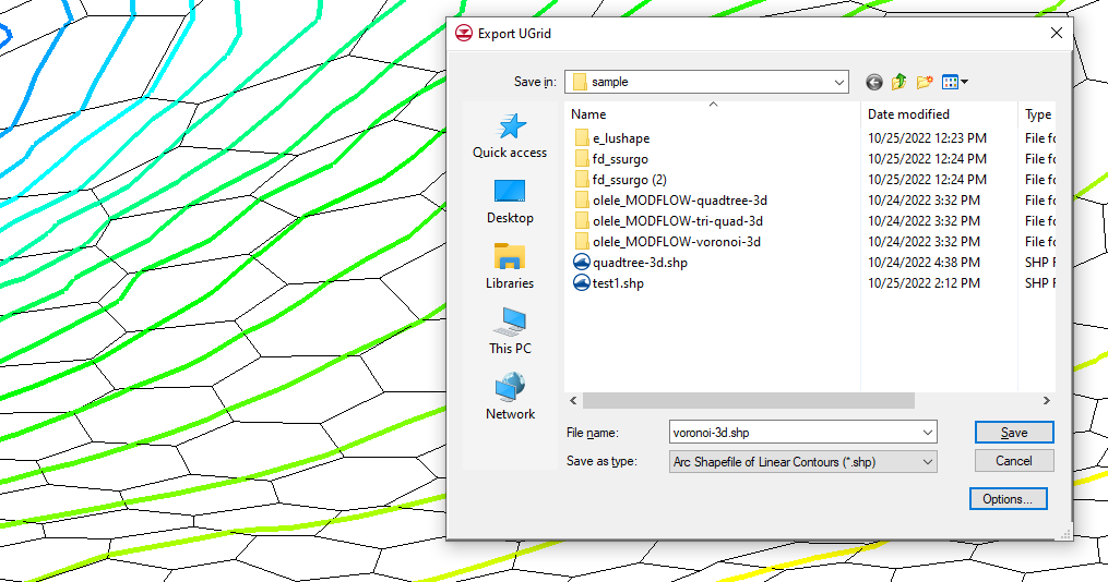
- Right-click on the active UGrid and select Export.
- In the Export UGrid dialog that appears, select "Arc Shapefile of Linear Contours (*.shp)" from the Save as type drop-down and save the contour shapefile with the desired name.
If you move the shapefiles, make sure to move them with all of their accompanying files. That includes the files ending in "*.dbf", "*.prj", and "*.shx".
There may be breaks in the displayed faces of the UGrid when only showing the top or bottom face of a layer. This is because some adjacent cells are joined only by vertical cell faces; the edges of the top or bottom of the cells don't touch. Thus, when the vertical cell faces are hidden, there is only empty space. This often affects the display of the contours and the contour shapefiles.
Try exporting your UGrid contours as shapefiles in GMS 10.7 today!
December 7, 2022
|
View: 2740
|
Categories: GMS
|
By: <a class="mp-info" href="https://aquaveo.com/blog/author/admin">Aquaveo Staff</a>
About the Author

Performing a Silent Install of XMS (Passwords & Hardware Locks)
October 10, 2018
Computing Basin Curve Numbers in 9 Easy Steps
May 16, 2023
Converting a NET File to an INP File
May 9, 2018
Performing a Silent Install for ALS
October 27, 2021
Tips for Finding Information on the XMS Wiki
September 25, 2019
Best Practices for Modeling Complex Geometries
April 28, 2026
Managing MODFLOW 6 Data: Lists, Copy Period & CSVs
April 21, 2026
5 Concepts for Mastering Surface-water Modeling
April 14, 2026
Comparing Multiple Design Alternatives in One Project
April 7, 2026
Incorporating MODFLOW 6 Groundwater Energy (GWE)
March 31, 2026