We use cookies to make your experience better. To comply with the new e-Privacy directive, we need to ask for your consent to set the cookies. Learn more.
OC Hydrograph
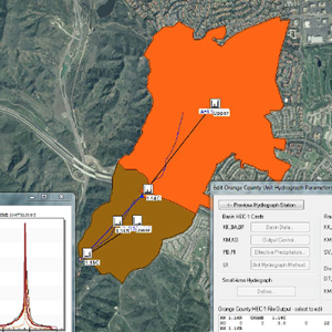
Compute Peak Flows of Large Urban Watersheds
Application:Urban Hydrologic Modeling
Method:Lumped Parameter
Model Type:1D
Developer:Orange County Public Works
OC Flood Division
Why OC Hydrograph with WMS?
WMS provides a custom interface to the OC Hydrograph model offering a simple way to set model parameters and a graphical user interface to run the model and visualize the results. Gather background data from a variety of sources from GIS to CAD and access online data from numerous databases of maps, images, elevation, land use, and soil data. WMS allows you to interact with models in true 3D taking advantage of optimized OpenGL graphics and to create photo-realistic renderings and animations for PowerPoint, print, and web presentations.
Try WMS Free for 14 Days >Purchase WMS with OC Hydrograph >
OC Hydrograph Description:
OC Hydrograph is used to compute peak flows on watersheds greater than 1 square mile in Orange County, California.