We use cookies to make your experience better. To comply with the new e-Privacy directive, we need to ask for your consent to set the cookies. Learn more.
WMS - Watershed Modeling System
All-in-one hydrologic & hydraulic
solutions including pipe networks
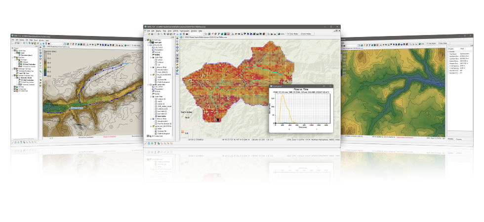
The complete all-in-one
watershed solution
- GIS Tools
- Web-based data acquisition tools
- Terrain data import and editing tools
- Automated watershed delineation & hydrologic modeling
- Support for the most industry standard hydrologic models
- Step-by-step hydrologic modeling wizard
- Hydraulic modeling & floodplain mapping
- Storm drain modeling
- 2D (Distributed) Hydrology
- Integration with FHWA hydraulic calculation software
- Export WMS animations to GoogleTM Earth
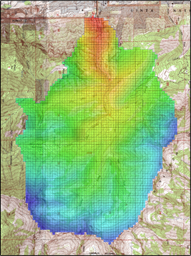
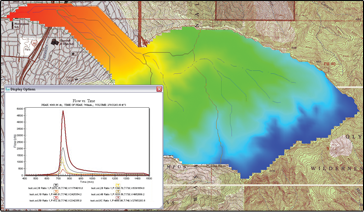
Automated watershed delineation
& hydrologic modeling
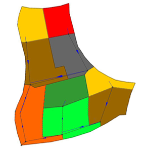
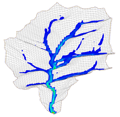
- Automatically delineate a watershed and sub-basins using digital terrain data
- Automatically compute geometric basin data such as area, slope, mean elevation, maximum flow distance and more
- With a small amount of input, compute hydrologic basin data such as time of concentration, curve number, and infiltration parameters
- Industry standard equations for computing sub-basin lag times and times of concentration are included with WMS
- Add any number of interior outlet points and let WMS subdivide the watershed automatically
- Manipulate stream networks to represent man-made features or proposed changes to the watershed
- Override derived basin boundaries to match your knowledge of the watershed
Support for most industry
standard hydrologic models
A license of WMS Floodplain or greater includes an interface for the following industry standard hydrologic models:
- HEC-1
- HEC-HMS
- TR-20
- TR-55
- Rational Method
- MODRAT
- OC (Orange County, California) Rational
- OC Hydrographic
- HSPF
- National Streamflow Statistics
- Convert and compare the results of a watershed developed for one model with any of the other models supported in WMS
- Read and compare observed hydrographs with computed hydrographs
Hydraulic modeling &
floodplain mapping
- Define a stream centerline and bank stations
- Define cross section locations
- Automatically cut cross sections and derive Manning's roughness values from elevation and ground material data
- Export cross sections to the HEC-RAS or Simplified Dam Break hydraulic models
- Run the hydraulic model and read the water elevations back into WMS
- Read water surface elevation data from a hydraulic model or manually input known water surface elevations
- Create flood extents and flood depth maps using digital terrain data and water surface elevation data points
- Link the peak flow or complete hydrograph from any of the WMS-supported hydrologic models to an HEC-RAS hydraulic model
Storm drain modeling
- Draw a storm drain network or import a network from GIS
- Compute elevations, lengths, and slopes of pipes from underlying elevation data
- Link the storm drain network to your hydrologic model data
- Export the hydrologic model data and the storm drain network to EPA-SWMM or XP-SWMM
- Import existing EPA-SWMM or XP-SWMM files into WMS
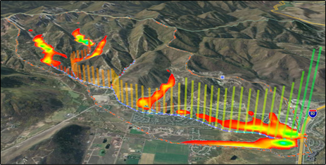
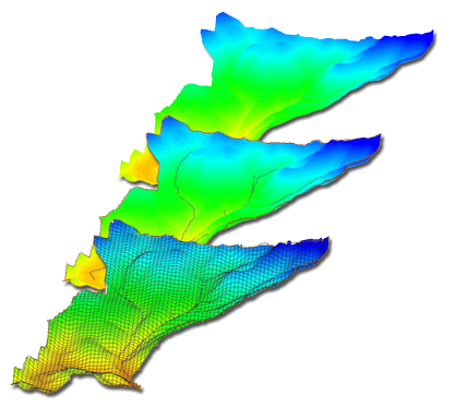
2D (Distributed) hydrology
- WMS supports 2D models:
- The US Army Corps of Engineers (USACE) GSSHA model
- The HMS version of the quasi-distributed MODClark method
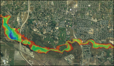
- Flood forecasting (depth and velocity over entire 2D domain)
- Thunderstorm (localized rainfall) flood analysis
- Surface ponding and infiltration analysis
- Wetland modeling
- Land use change impact modeling
- Groundwater/surface-water interaction modeling
- Sediment and contaminant modeling
Import what you need
- USGS DEMs - download and use any format of DEM from the USGS
- USGS NED data - seamless elevation data can be downloaded and read into WMS
- ArcGIS Raster (ASCII format) - read elevation or attribute data in gridded format from ArcGIS
- ESRI Shape files - read all shapes and attributes into WMS
- DXF and DWG CAD files - WMS now supports the latest versions of DXF and DWG
- TIFF, JPEG image files - /images along with geo-referencing information can be read by WMS
- Any data supported by ArcGIS can be read into WMS (ArcGIS license required, compatible with ArcGIS 10.0)
Software from an industry leader
WMS is developed by Aquaveo, an engineering services company with many years of experience developing watershed modeling solutions.
- Step-by-step tutorials and how-to videos
- Online community forum and product documentation
- Phone and email technical support
- Regularly scheduled training courses taught by expert modelers
- On-site training available
- Professional consulting services
WMS 11.4 System Requirements
- Operating System: Windows 11
- RAM: 16GB or more recommended
- CPU: Intel® or AMD® processor (x86-64). WMS software is CPU intensive. Some models and utilities integrated with WMS can take advantage of multiple processor cores simultaneously. We recommend the fastest CPU your budget allows.
- Storage: Recommended storage amount will vary depending on individual data requirements. Latest versions of WMS are very disk I/O intensive.
- Mechanical hard drive: Basic performance
- SATA solid state drive: Better performance
- NVMe solid state drive: Best performance - Graphics: A dedicated graphics card is better than integrated graphics. A basic or mid-range NVIDIA® card designed for gaming works best.
- Display Resolution: 1920 x 1080 or greater
Intel is a registered trademark of Intel Corporation or its subsidiaries.
AMD and the AMD Arrow logo are trademarks of Advanced Micro Devices, Inc.
NVIDIA is a registered trademark of NVIDIA Corporation.