Groundwater Analyst
Compatibility
Groundwater Analyst is compatible with:
- ArcGIS Pro
- ArcGIS Desktop
Tools in the Groundwater Analyst and ArcGIS will help you import data into your AHGW data model, manage key attributes, and visualize your data. Import a variety of datasets (wells, time series, cross sections, volumes) into your geodatabase, manage symbology of layers in ArcMap and ArcScene (ArcGIS Desktop), map and plot time series, and create common products such as water level, water quality, and flow direction maps.
An easy to follow tutorial is available for Groundwater Analyst.
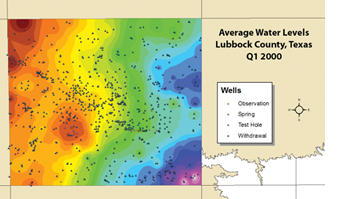
Manage Well Data
- Import well data from a text file
- Create maps to visualize well data using raster data sets
- Display flow vectors from flow direction generator
- Create maps to communicate various types of data
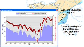
Perform Time Series Statistics
- Show average readings
- Show readings from a range of time
- Query time series data to generate maps
- Use the built-in spatial analyst tools to create raster /images