We use cookies to make your experience better. To comply with the new e-Privacy directive, we need to ask for your consent to set the cookies. Learn more.

Using Pre-Generated Polygons to Delineate a Basin
Delineating an accurate basin is an important part of a watershed project. WMS provides a number of tools for delineating a watershed basin. The Hydrologic Modeling Wizard is often used to step through the entire process of delineating a basin.
However, it is possible to delineate a basin using data from outside of the Hydrologic Modeling Wizard. In particular, the Drainage module contains tools for delineating a basin using existing project data.
For example, if you have a shapefile with polygons that gives the general outline of the basin, that shapefile can be used to delineate the basin. To use the shapefile polygons to delineate the basin, do the following:
- Import the shapefile into WMS. Verify the location is correct.
- If you have not already done so, add a DEM for the area of interest to the project.
- Generate the flow direction and accumulation, either by running TOPAZ/TauDEM or by importing it.
- Map the shapefile polygon(s) into feature polygons in a drainage type coverage.
- Place your outlet point(s) and digitize the streams. You can either manually draw the arcs, or load the streams from a shapefile. Be sure to verify that the arcs are set to Stream (not Generic) and that the directions are flowing from upstream to downstream (see "Stream Arrows" in the Drainage Display Options).
- Select DEM | Polygon Basin IDs -> DEM in the Drainage module.
- Select DEM | Compute Basin Data in the Drainage module.
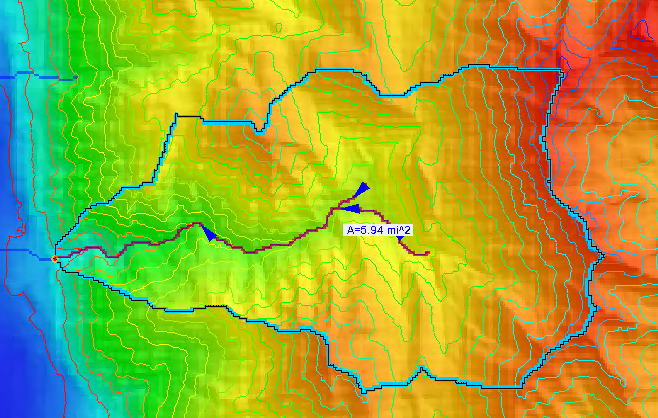
Once you have a delineated basin, you can use the basin with the watershed modeling model of your choice. Be certain to review the basin to make certain it contains all of the area you need for your project.
WMS provides a large amount of flexibility in delineating a watershed basin in order to adapt to the needs of your project. Try out the different basin delineation tools in WMS today!
August 26, 2020
|
View: 1916
|
Categories: WMS
|
By: <a class="mp-info" href="https://aquaveo.com/blog/author/admin">Aquaveo Staff</a>
About the Author

Performing a Silent Install of XMS (Passwords & Hardware Locks)
October 10, 2018
Computing Basin Curve Numbers in 9 Easy Steps
May 16, 2023
Converting a NET File to an INP File
May 9, 2018
Performing a Silent Install for ALS
October 27, 2021
Tips for Finding Information on the XMS Wiki
September 25, 2019
Comparing Multiple Design Alternatives in One Project
April 7, 2026
Incorporating MODFLOW 6 Groundwater Energy (GWE)
March 31, 2026
Essential DEM Clean-Up for Watershed Delineation
March 24, 2026
Essential Boundary Condition Guide
March 17, 2026
How to Delineate a Well Capture Zone Using MODPATH
March 10, 2026