We use cookies to make your experience better. To comply with the new e-Privacy directive, we need to ask for your consent to set the cookies. Learn more.

Editing DEM Elevations
Do you have a Digital Elevation Model (DEM) that has elevations that need to be adjusted? Editing DEM elevations can sometimes prove difficult. However, with WMS you can edit the elevations of DEM files using several tools WMS provides for editing DEM elevations.
Here are a couple ways DEM elevations can be edited in WMS:
Editing Single Points
Some DEMs have a single point where the elevation is off. You can edit a single point in a DEM by using the Select DEM Points tool and selecting the point. You can then edit the point elevation by double-clicking on the point to bring up the DEM Point Attributes dialog where the elevation value can be changed.
Using Feature Arcs to Edit Elevation
Sometimes, the elevation of a DEM needs to be adjusted to follow a specific line, such as a river bed or proposed irrigation channel. The elevation in this location can be adjusted using a feature arc. This is done by selecting the feature arc then right-clicking and selecting the Edit DEM Elevations command.
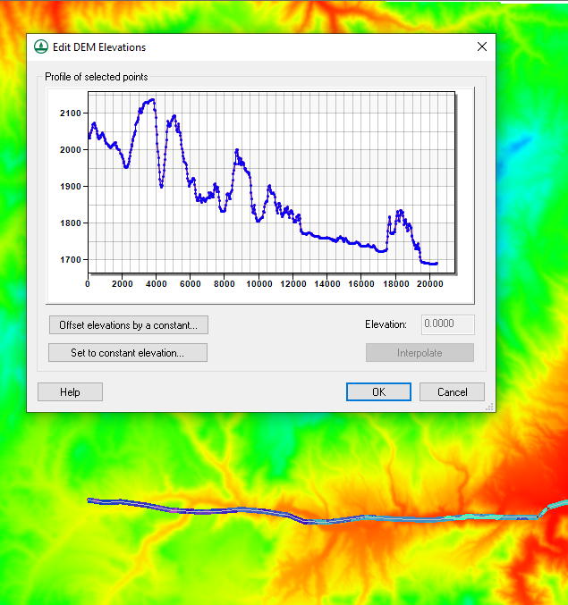
In the Edit DEM Elevations dialog, you can change the elevation of the DEM along the arc. This can be done by selecting and changing elevation points on the arc in the profile window. For editing all of the elevation values along the arc, the dialog provides the following options:
- You can offset all of the arc elevations by using the Offset elevations by a constant button.
- You can set all of the elevation values to a constant by using the Set to constant elevation button.
- Finally, you can use the Interpolate button to interpolate the values to between the first and last values on the arc. This will smooth out the elevation to create an artificial slope.
Using these tools makes adjusting the elevations of DEMs easier. Try them out in WMS today!
September 16, 2020
|
View: 3074
|
Categories: WMS
|
By: <a class="mp-info" href="https://aquaveo.com/blog/author/admin">Aquaveo Staff</a>
About the Author

Performing a Silent Install of XMS (Passwords & Hardware Locks)
October 10, 2018
Computing Basin Curve Numbers in 9 Easy Steps
May 16, 2023
Converting a NET File to an INP File
May 9, 2018
Performing a Silent Install for ALS
October 27, 2021
Tips for Finding Information on the XMS Wiki
September 25, 2019
Comparing Multiple Design Alternatives in One Project
April 7, 2026
Incorporating MODFLOW 6 Groundwater Energy (GWE)
March 31, 2026
Essential DEM Clean-Up for Watershed Delineation
March 24, 2026
Essential Boundary Condition Guide
March 17, 2026
How to Delineate a Well Capture Zone Using MODPATH
March 10, 2026