We use cookies to make your experience better. To comply with the new e-Privacy directive, we need to ask for your consent to set the cookies. Learn more.

Making Use of WMS Contour Labels
Does your watershed project need to display contour elevations values? WMS (as well as SMS and GMS) have the ability to use contour labels to help determine elevation levels at a glance, which can be very helpful for many projects, especially when modeling drainage. This post will review the different ways that contour labels can be utilized within WMS.
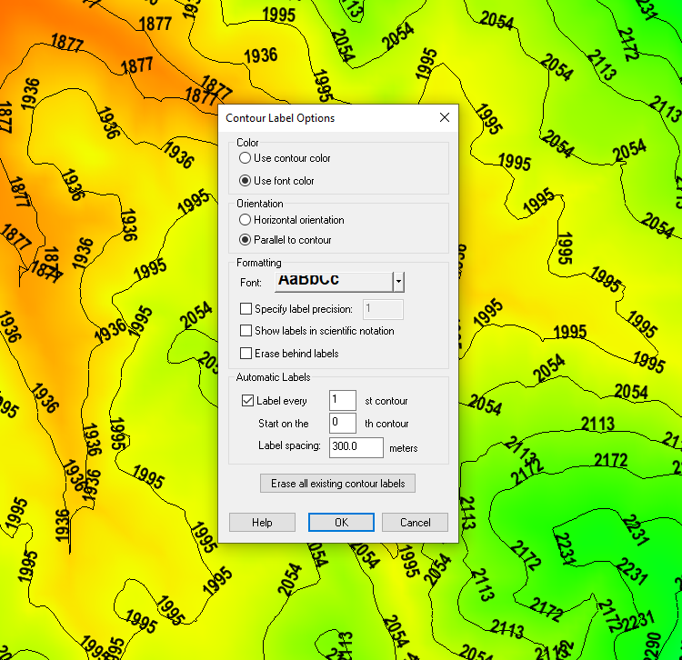
There are essentially two different forms or methods when it comes to applying contour labels to contours when working in WMS: manual and automatic. In both cases, the way contour labels are displayed can be modified in the Contour Label Options dialog, which can be accessed by clicking the Label Options… button when the Contour Options dialog has been brought up. Here there are options for color, orientation, font, scientific precision, etc. There is also a button to "Erase all existing contour labels" and start over from the beginning.
The manual method consists of using the Place contour label tool to click on contours and manually assign contour labels to the positions the user chooses. This option is only available in certain modules, such as 2-D Grid and Terrain Data. Note that these may disappear when options in the Contour Label Options dialog are modified, so it may be best to determine the contour options before you manually place contour labels. Labels can also disappear when contouring options are changed, when the Graphics Window is refreshed, or can even be manually deleted when holding down Shift and clicking on a label with this tool active.
The automatic method consists of using the Automatic Labels section in the Contour Label Options dialog to automatically populate labels along the contours. When activated, this allows you to set how many of the contours should be labeled, which contour to start with, and how far apart the labels are spaced out. Unlike in the manual method, changing options for these labels should not delete them, as they should automatically repopulate based on current settings when the OK button is clicked to close the Contour Label Options dialog.
While every project will be different, when using contour labels, some recommended settings to start off with would be to use "Color Fill and Linear" as the Contour Method, and to automatically space out labels. This way more discrete contours as well as gradient values can be easily displayed and it will be easy to determine at any given location what the elevation is. Also recommended is to avoid using white text in most instances, as it is usually difficult to read, except perhaps in instances where color fill is used.
Try out experimenting with contour labels in WMS 11.1 today!
December 8, 2021
|
View: 2361
|
Categories: WMS
|
By: <a class="mp-info" href="https://aquaveo.com/blog/author/admin">Aquaveo Staff</a>
About the Author

Performing a Silent Install of XMS (Passwords & Hardware Locks)
October 10, 2018
Computing Basin Curve Numbers in 9 Easy Steps
May 16, 2023
Converting a NET File to an INP File
May 9, 2018
Performing a Silent Install for ALS
October 27, 2021
Tips for Finding Information on the XMS Wiki
September 25, 2019
5 Concepts for Mastering Surface-water Modeling
April 14, 2026
Comparing Multiple Design Alternatives in One Project
April 7, 2026
Incorporating MODFLOW 6 Groundwater Energy (GWE)
March 31, 2026
Essential DEM Clean-Up for Watershed Delineation
March 24, 2026
Essential Boundary Condition Guide
March 17, 2026