MODFLOW Modeling with GMS
Advanced three-dimensional
groundwater modeling with MODFLOW
Dedication to MODFLOW support
- All versions of MODFLOW supported: 6, USG, LGR, NWT, 2005, 2000, 96, 88
- Many MODFLOW packages supported (see table below) with more to come
- Guaranteed to read any model that MODFLOW can run
- Support for MODFLOW related packages such as MODPATH, MT3DMS, MT3D-USGS, RT3D, PEST, and built in ZONEBDGT
- Full suite of manual and automated calibration tools including PEST, Parallel PEST, Monte Carlo simulations, calibration targets, plots and charts
- Large model support (grid cells, stress periods) with smart memory management and caching for maintained responsiveness
- Transient data support in real date/time format
- Interpolation of transient data
- Stochastic Simulation tools including Monte Carlo, Latin Hypercube, Gaussian Field, T-PROGS (better than indicator kriging) and Risk Analysis wizard for capture zone and transport analysis.
| MODFLOW Package | Description |
|---|---|
| BAS6 | Basic Package |
| BCF6 | Block Centered Flow Package |
| CHD1 | Time Variant Specified Head Package |
| DE4 | Direct Solver |
| DRN1 | Drain Package |
| DRT1 | Drain Return Package |
| EVT1 | Evapotranspiration Package |
| ETS1 | Evapotranspiration Segments Package |
| GAGE | Gage Package |
| GHB1 | General Head Boundary Package |
| GMG | Geometric Multi-Grid |
| HFB1 | Horizontal Flow Barrier Package |
| HUF | Hydrogeologic Unit Flow Package |
| LAK3 | Lake Package |
| LPF | Layer Property Flow Package |
| MNW1 | Multi-Node Well 1 Package |
| MNW2 | Multi-Node Well 2 Package |
| NWT | Newton Solver |
| OUT1 | Output Control |
| PCG2 | Preconditioned Conjugate Gradient Method |
| PCGN | Preconditioned Conjugate Gradient Solver with Improved Nonlinear Control |
| RCH1 | Recharge Package |
| RIV1 | River Package |
| SAMG | Algebraic MultiGrid for Systems Solver |
| SFR2 | Streamflow-Routing Package |
| SIP | Strongly Implicit Proceedure |
| SOR | Slice-Successive Overrelaxation Method |
| SUB | Subsidence Package |
| STR1 | Stream-Routing Package |
| SWI | Seawater Intrusion Package |
| WEL1 | Well Package |
| UPW | Upstream Weighting Flow Package |
| UZF1 | Unsaturated-Zone Flow Package |
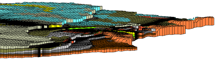
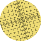
Structured or Unstructured Grid Options
MODFLOW
Traditional Grid
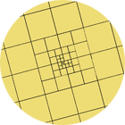
MODFLOW-USG
Quadtree Grid
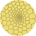
MODFLOW-USG
Voronoi Grid
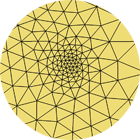
MODFLOW-USG
TriQuad Grid
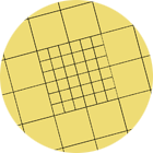
MODFLOW-LGR
Local Grid
GMS 10.0 supports a wide variety of structured and unstructured MODFLOW grids to provide the right solution for your modeling needs. Current GMS 10.0 licenses with MODFLOW receive MODFLOW-USG for free!
Full 3D visualization
From cross-section editing to advanced probability statistics, GMS offers unparalleled subsurface modeling tools.
- Real time panning, zooming and rotating in 3D
- Optimized OpenGL graphics for improved hardware rendering
- Texture mapping of images on surfaces
- Transparency of contours, texture maps, surfaces, iso-surfaces
- Light source and specularity
- Cut away views to see the inside
- 3D cross sections at any angle
- Iso-surfaces
- Create animation videos - create fly-bys, animate transient data, moving cross sections
Conceptual modeling
Discover the power and capabilities of MODFLOW & GMS with a free 2-week trial. Visit the Download Center for the latest full installation of GMS. A collection of GMS and MODFLOW tutorials are also available to help make learning GMS quick and easy.
The MODFLOW tutorials provide step-by-step instructions for:
- Grid independent representation of model features using GIS type objects (points, arcs and polygons)
- Grid independent representation of stratigraphy using solids
- Grid independent representation of stratigraphy using point data and interpolation to MODFLOW layers
- Display of background images of maps, aerial photos etc.
- 2D and 3D interpolation and geostatistics including kriging
GIS integration
- Tight integration with GIS data
- Open Geodatabases and Shapefiles directly in GMS
- Export Geodatabases and Shapefiles
- Integration with Arc Hydro Groundwater for powerful report and map generation inside ArcMap
- Worldwide global projection support including Cartesian and geographic (lat/lon)
User friendly interface
- Standard, intuitive, user-friendly windows interface
- Annotation tools for report generation
- Many step-by-step tutorials
- Complete help system
- Active forums with contributions from users and developers
- Full phone and email tech support
- Regularly scheduled training courses with expert modelers. On-site training available


