HydroGeoSphere - Tightly Coupled Groundwater & Surface Water Simulations
The world’s most powerful integrated hydrologic modeling platform
now supported by GMS
Application:Fully-integrated, variably saturated groundwater and surface water flow modelling (with evapotranspiration)
Method:Finite Element
Model Type:3D
Developer:Aquanty Inc.
Why use HydroGeoSphere?
It is well understood that groundwater and surface water flow as part of a single integrated system, and with the rapid acceleration of computational power in recent years, and the development of advanced simulation engines like HydroGeoSphere, it is now possible to model the full terrestrial portion of the hydrologic cycle.
HGS is the world’s most powerful integrated hydrologic modeling platform. HGS is a three-dimensional control-volume finite element simulator designed with an entirely physics-based approach to modeling groundwater/surface water hydrology. HGS uses a globally-implicit approach to simultaneously solve the 2D diffusive-wave equation for overland/surface water flow and the 3D form of Richards’ equation for variably saturated groundwater flow.
The HGS Interface for GMS currently supports the 2D surface flow, 3D variably saturated groundwater flow and evapotranspiration modelling capabilities of HydroGeoSphere, giving users all the processes they need to model water resources at the watershed scale. Additional feature support will be included in future releases of the HGS Interface for GMS
Try GMS Free for 14 Days >Purchase GMS with HydroGeoSphere >
HydroGeoSphere (HGS) Description
 HGS dynamically integrates key components of the hydrologic cycles and can incorporate land surface processes such as evaporation from bare soil, transpiration with evolving vegetation, unsaturated flow, flow in porous and/or discrete fractured media, and reactive solute and thermal energy transport within the overall hydrogeosphere. Macro pores, fractures, and tile drains can be incorporated discretely or using a dual-porosity, dual permeability formulation. The model can also simulate winter hydrological processes such as snow accumulation/melting and pore-water freezing/thawing.
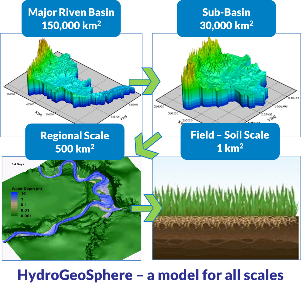
The HydroGeoSphere platform has been parallelized to utilize high performance computing facilities and to address challenging scientific and engineering problems such as the analysis of climate change impacts on water resources at the watershed, basin, and continental scales.
Note: the HGS Interface for GMS supports the most integral features/capabilities of the HGS modeling engine including 2D surface water flow, 3D variably saturated groundwater flow, and evapotranspiration. A full suite of boundary conditions and parameterization tools are available to support these basic flow capabilities. The feature set listed below (e.g. solute transport) is not representative of the features available through the HGS interface for GMS. Additional HGS capabilities may be implemented using the native HGS workflow (contact GMS sales/support for more information). For example, a flow model produced using the HGS interface for GMS may be modified using the native HGS workflow to incorporate solute transport, density dependent flow, fracture flow, etc. Future versions of the HGS Interface may expand on the HGS features/capabilities supported by GMS.
HydroGeoSphere Key Features/Capabilities
SURFACE AND GROUNDWATER MODELING
- Surface domain represented as 2-D overland flow.
- Subsurface domain consists of 3-D variably saturated flow.
- Surface/subsurface domains interact through physically-based fluid exchange.
- Temporally and spatially varying evapotranspiration based on land use.
- Impact of snowmelt on hydrologic regime.
- Accurate delineation and tracking of the water table position.
- Handling of non-ponding or prescribed ponding recharge conditions and seepage faces.
- Representation of fractured geologic materials with arbitrary combinations of porous, discretely-fractured, dual-porosity and dual-permeability media for the subsurface.
- Accommodation of storage, solute mixing and variable flow distribution along wellbores.
- Density-dependent flow and transport.
THERMAL AND SOLUTE TRANSPORT MODELING
- Simulation of non-reactive and reactive chemical species transport in surface and subsurface.
- Heat transport in the associated surface and subsurface flow fields.
- Accurate handling of fluid and mass exchanges between fractures and matrix.
- Matrix diffusion effects and solute advection in the matrix.
- Calculation of water age and solute transit time probabilities.
ADVANCED NUMERICAL METHODS
- Fully-implicit coupling approach for all domains provides for a robust, mass conserved solution scheme.
- Advanced computational algorithms that allow the code to perform unprecedented, fully-integrated, 3-D simulation on a personal computer.
- Adaptive time-stepping schemes with automatic generation and control of time steps.
- Fluid and solute mass balance tracking.
- Unstructured finite-element grids.
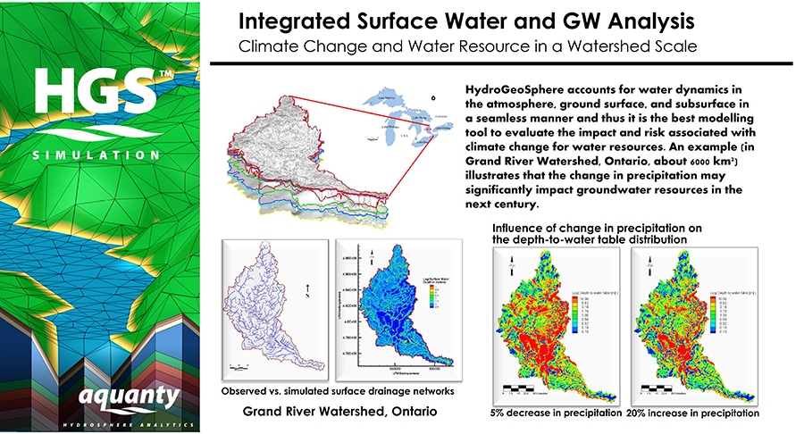
Climate Change and Water Resources in a Watershed Scale
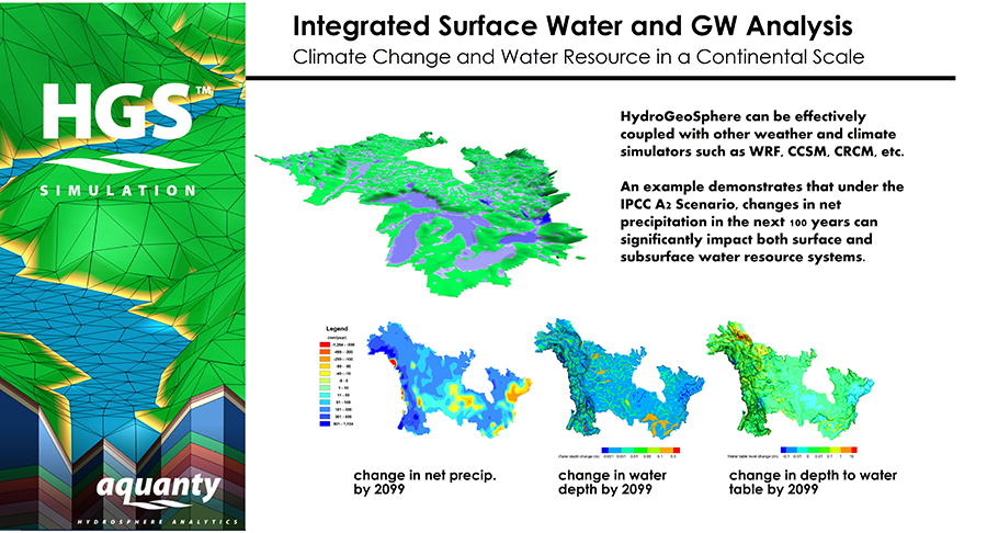
Climate Change and Water Resources in a Continental Scale
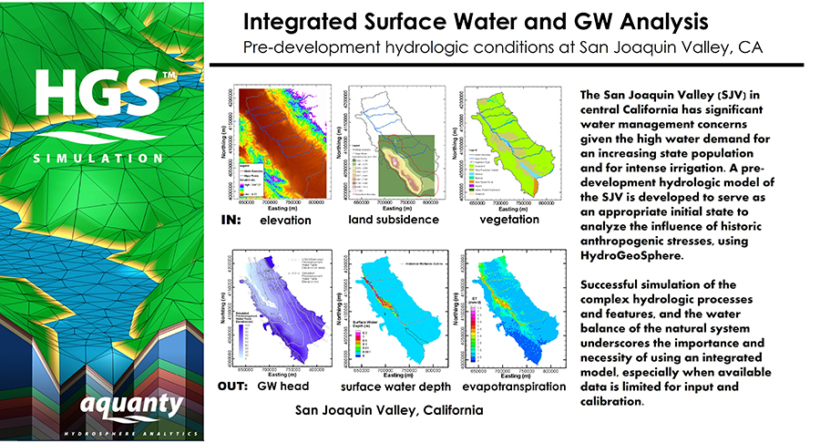
Pre-development hydrologic conditions at San Joaquin Valley, CA
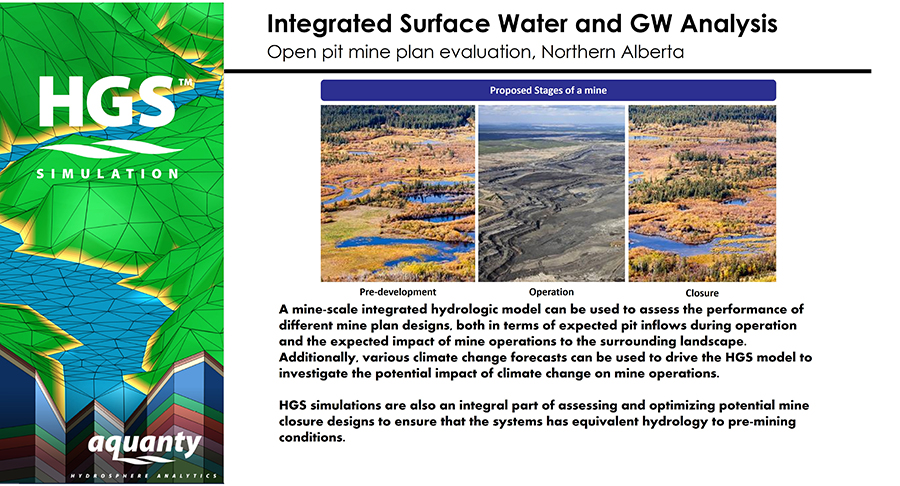
Open pit mine plan evaluation, Northern Alberta
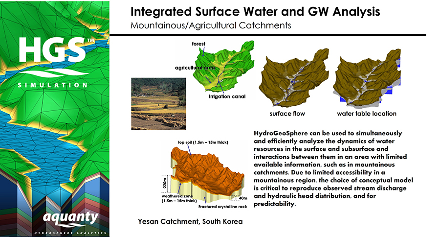
Mountainous/Agricultural Catchments
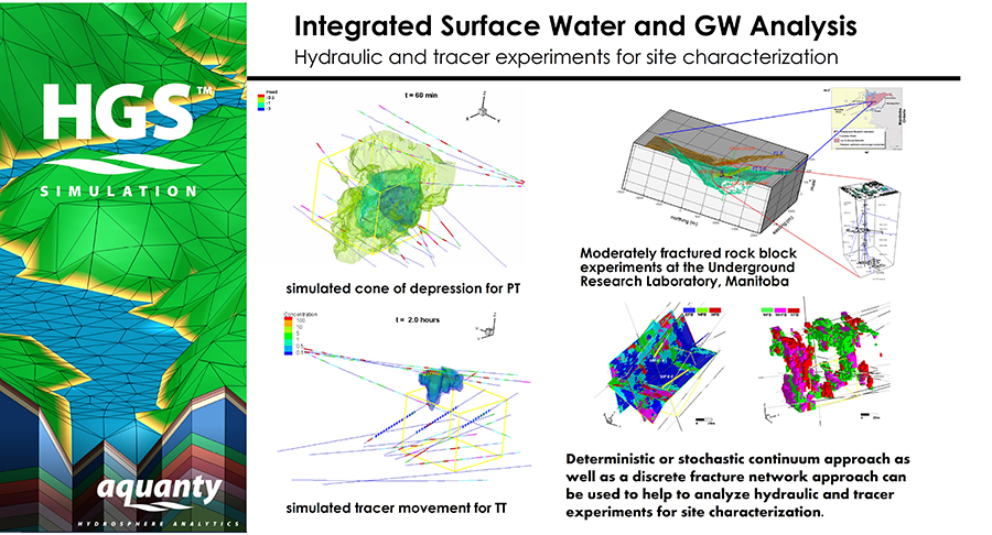
Hydraulic and tracer experiments for site characterization
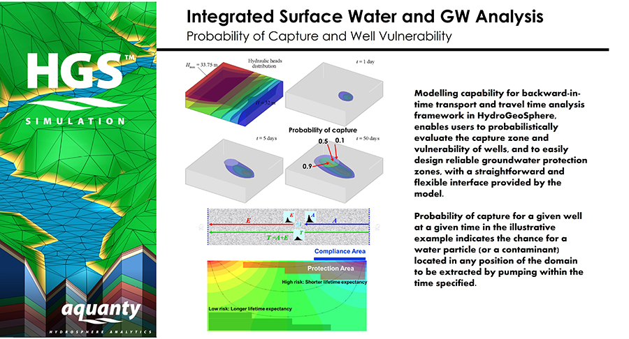
Probability of Capture and Well Vulnerability
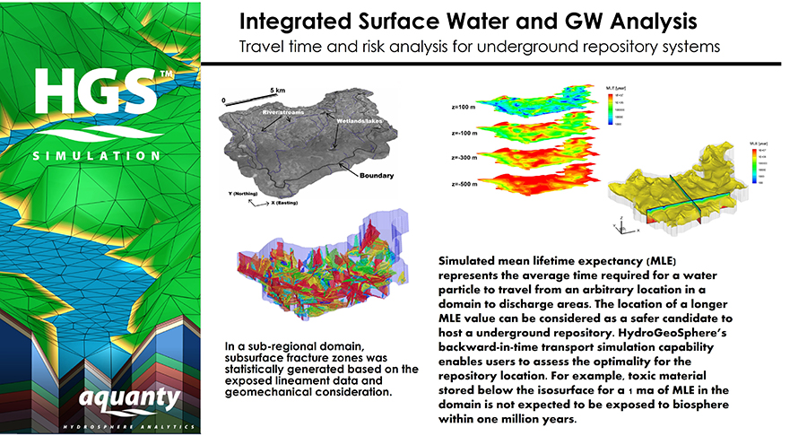
Travel time and risk analysis for underground repository systems
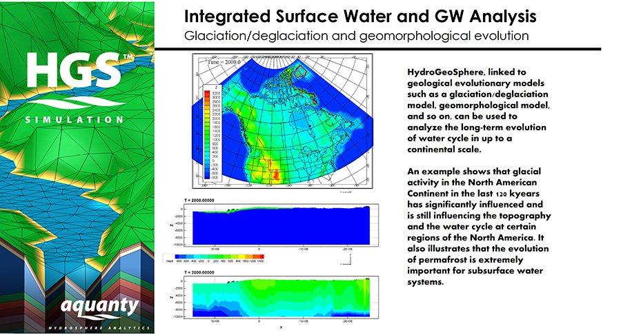
Glaciation/deglatiation and geomorphological evolution
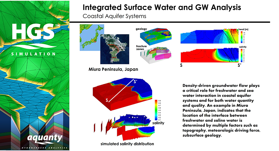
Coastal Aquifer Systems