We use cookies to make your experience better. To comply with the new e-Privacy directive, we need to ask for your consent to set the cookies. Learn more.

3 Ways to Troubleshoot WMS Basin Issues
Have you noticed your model’s basin isn't what you hoped it to be? When you create a solid watershed model, there are a few common issues that can make the model not work as intended. These include:
- Having a flow accumulation threshold that is too low or too high.
- Having one or more outlets in the wrong location for proper definition of the sub-basins and basins.
- Trying to work with a project area that is too large or too small for the intended purpose.
Flow Accumulation Threshold
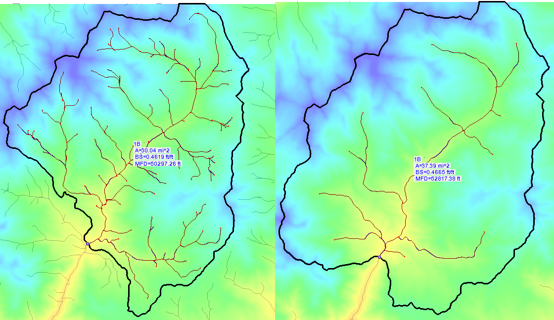
Setting the correct flow accumulation threshold is very important. If you set the flow accumulation threshold too low, it may not accurately show the information you need, leaving sections of the watershed model reporting dry conditions. If you set it too high, you can be overwhelmed with too much information. It is good practice to try multiple levels to see which provides the most accurate results for the project. You can adjust this setting by doing the following:
- Open the Hydrological Modeling Wizard dialog.
- Select Compute Flow Directions and Accumulations (TOPAZ) from the list on the left.
- Enter the desired Min flow accumulation threshold and close the dialog.
Adjusting the Outlet
Placing an outlet in the wrong location causes the entire structure of the stream system to change dramatically. This can produce sub-basins quite different than desired, which can lead to results not lining up as expected. Remember that everything upstream from an outlet will be part of the same sub-basin or basin, so be careful when placing your outlets for each sub-basin as well as for the full basin.
Project Area
Sometimes, you may select a larger area than necessary for your model, or you may select an area too small for the project to produce useful results. If the area is too large, the desired details may not show up in your results. If the selected area is too small, you may not have enough data on which to base your decisions for the watershed.
If you keep these ideas in mind, your watersheds will better represent the areas you're modeling. Experiment with this today in the WMS Community Edition.
June 13, 2018
|
View: 3180
|
Categories: WMS
|
By: <a class="mp-info" href="https://aquaveo.com/blog/author/admin">Aquaveo Staff</a>
About the Author

Performing a Silent Install of XMS (Passwords & Hardware Locks)
October 10, 2018
Computing Basin Curve Numbers in 9 Easy Steps
May 16, 2023
Converting a NET File to an INP File
May 9, 2018
Performing a Silent Install for ALS
October 27, 2021
Tips for Finding Information on the XMS Wiki
September 25, 2019
Best Practices for Modeling Complex Geometries
April 28, 2026
Managing MODFLOW 6 Data: Lists, Copy Period & CSVs
April 21, 2026
5 Concepts for Mastering Surface-water Modeling
April 14, 2026
Comparing Multiple Design Alternatives in One Project
April 7, 2026
Incorporating MODFLOW 6 Groundwater Energy (GWE)
March 31, 2026