We use cookies to make your experience better. To comply with the new e-Privacy directive, we need to ask for your consent to set the cookies. Learn more.

Two Tools for Creating a Raster from a Dataset
Do you have solution data that you want to export as raster data? The Surface-water Modeling System (SMS) provides two tools to help you create rasters from datasets. In this blogpost we will discuss the WSE/Depth Raster from Dataset tool and Raster from Dataset tool as well as the uses for both these tools and the differences between them.
WSE/Depth Raster from Dataset tool and Raster from Dataset tool are two separate tools in the SMS Toolbox. Each addresses the process of converting datasets to rasters, but with some differences.
To start, it should be noted that both tools are designed for creating raster data from solution datasets. This means that your project should contain solution data from a successful model run. Also, both tools allow you to define the pixel size of the resulting raster.
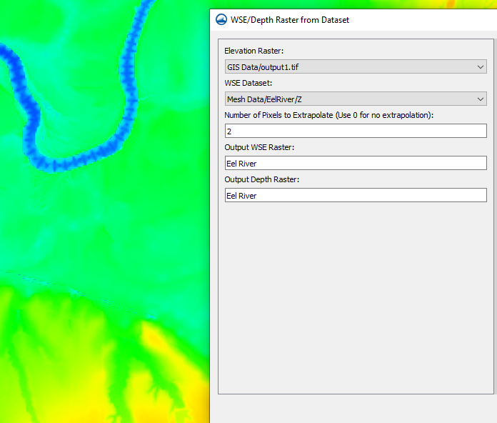
The WSE/Depth Raster from Dataset tool creates a raster based on water-surface elevation (WSE) or depth data. The tool requires that you have a geometry containing a WSE or elevation solution dataset in your project and that you have a raster containing the project elevation. It can extract both a WSE raster and a depth raster from a single tool execution. The tool is designed specifically to work with the bathymetry data. Other datasets may be converted incorrectly when using the WSE/Depth Raster from Dataset tool.
For other solution dataset on a geometry, the Raster from Dataset tool can create a raster from those datasets. This tool will work with datasets on various geometries including meshes, scatter sets, and unstructured grids (UGrids). The tool also allows you to use a raster template to define the output origin, activity, and possible resolution.
Now that you know some of the similarities and differences between the WSE/Depths Raster from Dataset tool and the Raster from Datasets tool, try out both of these tools and other features in the SMS Toolbox today!
December 12, 2023
|
View: 1975
|
Categories: SMS
|
By: <a class="mp-info" href="https://aquaveo.com/blog/author/admin">Aquaveo Staff</a>
About the Author

Performing a Silent Install of XMS (Passwords & Hardware Locks)
October 10, 2018
Performing a Silent Install for ALS
October 27, 2021
Tips for Finding Information on the XMS Wiki
September 25, 2019
Computing Basin Curve Numbers in 9 Easy Steps
May 16, 2023
Converting a NET File to an INP File
May 9, 2018
Enhancements to the 3D UGrid from Rasters Tool
October 28, 2025
How to Import and Use NOAA Tide and Water Data
October 21, 2025
Using Observed Data for Better Models
October 14, 2025
GMS 10.9 Beta: New Tools for Advanced Groundwater Modeling
October 7, 2025
How to Create and Export Stream Networks from Terrain Data
September 30, 2025